I thought I would post a link to this video on my blog, not running related but something that happened me today, warning I do swear in this video (a s**t and f**k, out of shock and annoyance):
Cycling home I hit a couple of large potholes at speed (around 20-25mph) and had a double blowout. Lucky for me I didn’t come off the bike, damage wise I haven’t been able to do a full assessment yet but I am hoping its just the tubes that need replacing.
I was not that far over to the left, but probably more than I would have liked and I have cycled this section of road many times and not had an issue (although not in the last few weeks).
As I say in my video, this (among other safety reasons) is a perfect example of why we have to keep to the right at times.
I have a running update which I will be posting in the near future
Never be satisfied with what you achieve, because it all pales in comparison with what you are capable of doing in the future. (quote – Rabbi Nochem Kaplan)
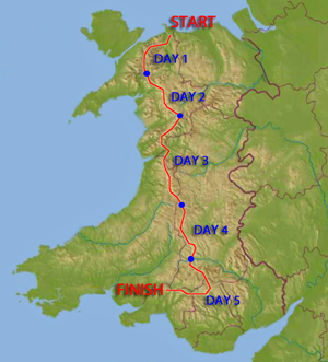
The legendary Dragon’s Back Race™ follows the mountainous spine of Wales from Conwy Castle to Carreg Cennen Castle. This incredible 5-day journey is approximately 300 kilometres long with 17,000 metres of ascent across wild, trackless, remote and mountainous terrain. It is not a trail race.
The original Dragon’s Back Race™ happened just once in September 1992 and ever since, it has been whispered about with a mix of awe and trepidation. Its reputation had reached legendary status with fell, mountain and ultra runners the World over by September 2012 when the second Dragon’s Back Race™ happened.
Many had considered the 1992 Dragon’s Back Race™ to be the toughest mountain running event ever organised. However, the 2012 route was harder still and included all the Welsh 3,000ft mountains on the first day, a number of additional summits on the other days and less road running throughout.
The Dragon’s Back Race™ is one of the hardest mountain races in the World.
The Route
The Dragons Back Race Route across Wales
Day 1
Carneddau, Glyders and Snowdon area
Straight line distance and height gain: 30 miles (48 km) / 19,700 ft (6,000m)
Day 2
Moelwyns and Rhinogs area
Straight line distance and height gain: 27 miles (43 km) / 14,700 ft (4,500m)
Day 3
Cadair Idris and Plynlimon area
Straight line distance and height gain: 34 miles (54 km) / 16,400 ft (5,000m)
Day 4
Elan Valley area
Straight line distance and height gain: 37 miles (59 km) / 11,500 ft (3,500m)
Day 5
Black Mountain area
Straight line distance and height gain: 34 miles (54 km) / 11,100 ft (3,400m)
Steeped in history this race has captured my imagination ever since I first saw the details back in early 2012 and the announcement of the next race in 2015 has inspired me to try to get the necessary experience to be considered for entry. That may seem a little vague in commitment but as part of the entry process the prospective entrant has to have a certain amount of experience to even be considered for such tough challenge, at a minimum it is the following:
Ultra Distance Races
Multiday Races
Mountain Running
Navigation in the Mountains
The way it works is that you pre-register on 1st April 2013 and then have until 8th September 2014 to tick all the boxes, if deemed to have the necessary experience you are then eligible for consideration, with 50% entry’s going to those with the best/most comprehensive experience and the other 50% pulled from a hat at random (if deemed to have above the minimum experience needed), so as you can see just getting to the consideration stage is an achievement.
People reading this may think that I am insane for even considering this, given the sheer amount of experience that is needed and the difficultly of the challenge itself, but I want to aim high and set my goals to the limit of what is achievable (as per the quote in the title).
If nothing else, the journey in getting this experience for the next year and a bit will be an achievement that I will be proud of and if, with a lot of effort and a little luck I am successful in entry I will be set to do something very special indeed.
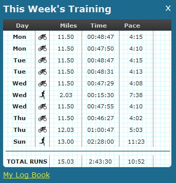
So my count down on the blog says that the NDW50 is only 2 months away, slightly inaccurate but still it’s just around the corner! This was the first week of the training plan to build me back up to running fitness and although it didn’t go completely to plan overall I am pleased
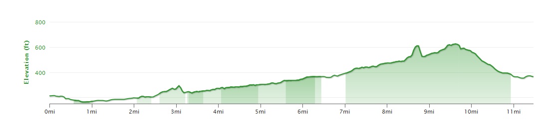
Cycling wise, I commuted as planned 4 days of the week and covered the planned 92 miles for the week. The weather was relatively ok although every morning I was met with a strong head wind which would just make things that little bit tougher. The route I am now taking to work has a but more hill than before and rather than being 10 miles is around 11.5, the route home is pretty much up hill all the way back.
The hill profile of my commute home, total of around 620ft
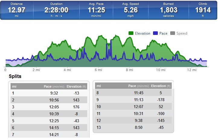
Running for the week consisted of a 2 mile run at (for me) a fast(ish) pace along a pretty flat route on the roads and just under 13 miles on the Sunday.
The run was along the North Downs Way and the trail had improved with the drier weather, but there were still sections of quite sticky mud and I ended up turning back along the section that runs just before you hit Oxted Downs. Where the ground is clay, it was like an ice rink with slippery wet clay meaning I was tip toeing along and I just decided that I would rather turn back and extend my run the other way or risk walking the whole of that part of the trail. As it was this decision was a good one as about 2 miles from home I got a call from my wife saying that one of my boys had caught that bug that his brother had been suffering with earlier that week, so I opted to cut the run short.
The stats from my run along the North Downs
Although I had to cut things short I was pleased with my run, this was one of the first long runs where I had felt comfortable and felt as though I had the energy to keep going longer if I had wanted.
With a bit more confidence in my running and my Achilles seemingly sorted, I am looking forward to more long runs.
Didn’t get as much running done as planned this week, however I did manage to cycle 4 out of 5 days so covered around 90 miles over the week.
Running wise it was a 9.90 mile run over the Downs on a very cold day, with an icy wind that resulted in my fingers losing all sensation despite wearing gloves. I had planned on doing around 20 miles but a late start (and the cold if I am honest) resulted in me cutting things short.
On this run I also decided to try out the GoPro head strap that I purchased recently, to see what how the different perspective changes things. I have put together a short film taking various clips from my run and uploaded it to YouTube.
Training wise, it dawned on me today that the NDW50 is only 12 weeks away and actual training has been pretty much non existent. I need to step things up now to be in with a chance of actually being fit enough to run it.
I have been looking online for a planning website where I can upload all my runs, plan future runs and training as well as nutrition. I happened across Training Peaks which does all of the above as well as including an Android App, however the free account you can only log historical activities and have to pay a premium ($19.95 per month) for all the planning features. At this stage I am not prepared to pay that much per month so will be using a website which I am already a member of, Good Run Guide.
Here you can still add training plans for all activities, not just running, but at the sacrifice of nutrition and an Android App (although they do have a web app which at first glance does the job). I have added the activities that I would like to do on the planner and will be sticking to this, below is the next 4 weeks (The cycle to work may get replaced with a run here and there but that will be more of an ad hoc thing).
As I mentioned in my Training Update this is something that I have wanted to do for a while, these videos shows the North Downs Way from Gravelly Hill to Botley Hill, two checkpoints for the Centurion Running North Downs Way 50 and 100
My idea was to try and help runners who won’t have the opportunity to run the route prior to the events by pointing out some of the key junctions along the way.
This is not originally how I wanted to present this as I have had to cut all of the sped up sections inbetween to keep the file size down and I still need to edit and upload Part 2 but will get this on ASAP
My full plan is to film as much of the North Downs Way as possible and upload it to YouTube, so if viewers have any comments or feedback as how best to improve future videos let me know.